Surveys |
Surveys can be broken into two distinct types. The first type is where we gather Information and then convert the information
into a plan of survey. This plan is then forwarded to our client in both hard copy format (Paper) and or Electronic format (digital information).
The information gathered by survey is then utilised to determine or to create as the case may be.
The second type of survey is where we convert design into spatial reality. Building Setout surveys are a good example of this type of survey.
Surveyors are the medium between design and spatial reality. The reality is that boundaries form the framework of our existence. The knowledge of where those boundaries lie is the key to success.
Knowledge provides peace of mind and Surveyors can provide you with spatial knowledge. If you are uncertain about the type of survey you require search the list below and preview some examples of the types of Survey we can undertake and the Plans of Survey that we produce.
|
Services |
We are a local family owned and run business. As such we provide a personalised service to our clients where
our clients deal directly with the surveyor. Our surveys are competitively priced and we always achieve the best outcome for our clients within the given time frames. We are not limited to the list below so if you are uncertain about your requirements contact us and let us
guide you through.
|
1. |
|
|
1.1 |
Lot Reconfigurations (Standard Format Plan) (Subdivision) |
|
Types of Lot Reconfiguration surveys available in Queensland are as follows |
(a) |
Plan of Lot Reconfiguration (Subdivision) survey where one or more existing lots are |
|
subdivided
into at least two new lots. Local Authority approval required prior to
undertaking survey |
|
|
(b) |
Plan of Amalgamation Survey where at least two existing lots are amalgamated into |
|
a single
lot. No Local Authority approval necessary. This type of survey plan is also |
|
frequently used to
cancel Community Title Schemes and in many cases a plan can |
|
be drawn without the need
for field survey. This type of survey plan is known as a |
|
compiled plan |
|
|
(c) |
Plan of Boundary Re-alignment survey where the position of the common boundary |
|
between adjoining properties is changed. Local Authority approval required prior to undertaking survey.
This type of survey is frequently used to alleviate encroachment |
|
|
|
|
1.2 |
Identification (Boundary Reinstatement) |
|
An Identification Survey is a survey that reinstates your property boundaries. Survey pegs are
placed at the corners of your property and line pegs can be placed at indivisable points along
a boundary. The Survey and Mapping Infrastructure Act 2003 and the Surveyors Act 2003 and
Associated Regulations and Standards sets the requirement that if a mark is placed that purports
to be a survey mark then a plan of survey must be lodged with Department of Environment and
Resource Management (DERM). While a plan of Identification Survey is lodged with this Department
for survey Information only it is not a Registered Survey Plan |
|
|
1.3 |
Community Title Scheme (Strata Title) |
|
Types of Lot Reconfiguration surveys available in Queensland are as follows |
(a) |
Standard Format Plan with Common Property |
|
This type of subdivision replaces the old Group Title Plan subdivision (GTP) and is a
subdivision of land which creates at least two new lots and common property under a
Community Title Scheme. |
(b) |
Building Format Plan (BFP)( Subdivision of building) |
|
This type of survey subdivides an existing building situated on one or more lots into at least two or
more new lots and common property under a Community Title Scheme and replaces the
old Building Units Plan (BUP) |
|
|
(c) |
Plan of Group Title Re-Subdivision |
|
As mentioned above this type of survey was a subdivision of land creating at least two
new lots and common property under a Community Title Scheme. While this type of
survey has been replaced by 2a above there are still a number of parcels existing that
can be subdivided that were created by the GTP type subdivision. The re-subdivision
of such lots is done by a Plan of Group Title Re-subdivision |
|
|
| (d) |
Exclusive Use Surveys |
| |
In a Building Format Plan Community Title Scheme the land outside the building is defined
as Common Property. A survey plan of exclusive use areas defines parts of the Common
Property over which a lot within the Community Title Scheme has exclusive use |
| |
|
| (e) |
Services Location Diagrams |
| |
Services location diagrams are prepared as diagrammatic representations of the location of
services within the common property. The services location diagram forms an integral part of
the Community Management Statement (CMS) |
| |
|
|
|
1.4 |
|
|
From the Land Title Practice Manual:
'An easement is a right annexed to land to utilise other land in a particular manner.'
There are many reasons for the creation of an easement over a property. For example easements
can be created for access or to allow Local Authorities to have infrastructure such as stormwater
drainage passing through your land |
|
|
1.5 |
|
|
(a) |
Lease over all or part of a lot (land lease) |
|
|
(b) |
Lease over all or part of a building (Building Lease) |
|
|
|
1.6 |
|
|
This type of survey is generally used to provide information on the position of existing buildings or
structures in relation to the property boundaries. The building location survey is generally used
when a full detail or identification survey is not required.
|
|
2. |
|
|
2.1 |
|
|
This type of survey provides information for Architects, Engineers, Town Planners, Building Designers, Builders and Draftsmen
in relation to spot levels, contours, existing buildings and overhangs, existing visible services, street furniture, trees and
any other features, detail or information that may result in constraints or advantages for a proposed development. While a
plan of contour/ detail survey depicts the subject property boundaries the survey does not reinstate the boundaries. |
|
|
2.2 |
|
|
This type of survey is used to peg or mark on the ground the external corners, floor level step-downs, pier or column positions and any
other part of a proposed structure for the purpose of construction. We can provide assistance and advice in relation to the proposed set-out,
offsets for recovery of corners and the number of visits required to complete the job. We provide a plan of set-out prior to construction and a
Form 16 certification upon completion with every set-out survey. We have vast experience in building set-out and we will be able to satisfy
your requirements regardless of the size or type of building to be constructed. |
|
|
2.3 |
|
|
We can provide this service for a wide range of engineering projects including but not restricted to the construction of roads, batters, building pads, bridges,
sewer, stormwater and water lines. We will provide you with a plan of set-out and certification with every survey. |
|
2.4 |
|
|
This service will provide you with certification upon completion and plans of as constructed survey for your project that will satisfy Local Authority requirements.
|
|
2.5 |
|
|
Level surveys are undertaken to provide either a temporary benchmark on site or to provide a reduced level for an existing feature on site. An example of this
would be to provide a floor level of an existing building. The reduced levels (RLs) provided are generally related to AHD (Australian Height Datum) and
originate from a local Permanent Survey Mark (PSM) of known Reduced Level (RL). Certification is provided upon request by way of Form 16.
|
|
2.6 |
Dilapidation and Monitoring |
|
The purpose of this type of survey is to provide information with regards to movement, over a period of time, of a
failed or failing structure. The structure such as a wall, footing, concrete slab or earth pad will be monitored for
movement over a period of time and the results will be provided in report form with a plan of survey. |
|
|
|
3. |
Applications, Preliminary Plans & Reports |
|
3.1 |
Local Authority Lot Reconfiguration (Subdivision) Applications) |
|
We can provide Lot Reconfiguration proposal plans and Council Applications
including subdivision and boundary realignment |
|
|
3.2 |
Identification Survey Reports |
|
A report to accompany the plan of survey can be provided upon request. Generally speaking our survey
plans will depict any encroachments or other potential problems associated with boundary reinstatement
and in most cases a separate report is not required. |
|
3.3 |
|
|
As surveyors we have a responsibility under the Survey and Mapping Infrastructure Regulations 2004 to notify
all affected owners in the case of building encroachment. If an encroachment is found during the course of our survey
will we notify you and any other affected party of the extent of encroachment by way of report and Notice of Encroachment.
Encroachment can be dealt with by the following methods. (See example identification survey above) |
(a) |
Removal of the encroachment |
(b) |
Easement over the encroaching building (Requires approval from all affected parties) |
(c) |
Boundary realignment (Requires approval from all affected parties) |
|
|
3.4 |
Preliminary Building Format Plans |
|
We can prepare all forms of preliminary plans. Generally these plans are prepared for the purpose of sales contracts
|
|
|
3.5 |
|
| |
Location certificates are reports, generally prepared for the purchaser of a property, which certify the
location of the propertry being purchased. The certificate reports on the location of the property in relation
to the nearest street intersection, a description of the existing buildings on the property, the type/s of fencing
on the boundaries, photographs and other information that helps define the location of the property being puchased.
|
|
| 3.6 |
Dilapidation and Monitoring Reports
|
| |
|
|
4. |
|
|
4.1 |
Understanding Survey Abbreviations |
|
Many abbreviations are used on the face of our survey plans. The attached list, whilst not exhaustive, may help you
understand these abbreviations |
|
To learn the meanings of different survey abbreviations Click Here |
|
|
| |
|
|
|
|
|
|
|
|
|
| |
Address: |
|
Po Box 40 |
|
|
Chirn Park |
|
|
Queensland 4215 |
Phone: |
|
0755915238 |
Mobile: |
|
0417757108 |
Fax: |
|
0755915238 |
|
| |
Email Us |
| |
To send us an email complete the details below and then click on the "Send"button |
| |
|
| |
|
| |
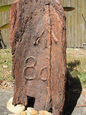
A Little Piece Of History |
|
.
ORT FOUND
In earlier times surveyors referenced boundary corners by cutting a shield into a nearby tree and chiseling the portion or lot number and a broad arrow into the heartwood.
Measurement was then made to the tip of the broad arrow.
This is a photo of remaining evidence of this practice after 120 years. This tree was referenced on W311259, the original portion number was 68. Have you worked it out yet?
The original shield in the tree had grown over and the heartwood died leaving the tree hollow on the inside. The mirror image and reverse numbers were created by the regrowth. To view the original survey plan Click Here
|
| |
|
| |
|
Historical collection of survey pegs |
| |
|
|
|